


Garmin ECHOMAP Plus 42cv

Please sign in so that we can notify you about a reply
A Great Addition to Any Fishing or Boating Trip
- Bright, sunlight-readable 4.3” combo
- Includes GT20 transducer for Garmin CHIRP traditional sonar plus CHIRP ClearVü™ scanning sonar with transom and trolling motor mounts
- Preloaded worldwide basemap; compatible with BlueChart® g3 and premium BlueChart® g3 Vision coastal charts with integrated Navionics® data and Auto Guidance¹ technology
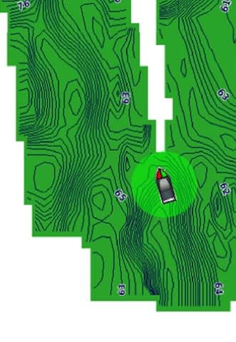
- Built-in Quickdraw Contours mapping software instantly creates personalized fishing maps on-screen with 1’ contours as you fish
- Share waypoints and routes with other ECHOMAP™ or STRIKER™ units

This compact combo has lots of built-in benefits. Easy-to-install and even easier to use, it has a bright screen 4.3” display that is easy to read on a sunny day on the water. It includes a GT20 transducer for traditional Garmin CHIRP sonar that delivers remarkable target separation and CHIRP ClearVü scanning sonar for nearly photographic images of what’s below the boat. It comes with a preloaded worldwide basemap and is compatible with our BlueChart g3 and premium BlueChart g3 Vision coastal charts with integrated Navionics data and Auto Guidance1 technology. Plus, it has Quickdraw Contours mapping software to instantly create personalized fishing maps on-screen with 1’ contours as you fish. You own these maps. They are yours to keep private or share with the Quickdraw Community on Garmin Connect™. Plus, you can share waypoints and routes with other ECHOMAP or STRIKER units. It also features a quick-release mount allowing you to quickly install and remove your device from power and mount. Transom and trolling motor mounts included.
The Garmin CHIRP Difference
The built-in sonar capabilities of ECHOMAP Plus 42cv include our CHIRP traditional sonar, one of the most sophisticated sonar technologies available for the fishing and boating public. CHIRP traditional sonar provides amazingly clear target separation and definition, because it puts even more energy onto the target than traditional sonar. It also provides traditional sonar support for Minn Kota® and MotorGuide® trolling motors with integrated transducers.
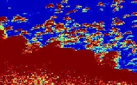
Clear Scanning Sonar Images
Garmin CHIRP ClearVü scanning sonar gives you a nearly photographic image of what’s below your boat. You clearly see structure, submerged objects and fish. Garmin CHIRP traditional sonar and CHIRP ClearVü scanning sonar are combined into 1 transducer.

Quickdraw Contours to Create Your Own Maps
Instantly create personalized fishing maps on-screen with 1’ contours as you fish. Tailor them to fit your needs. These are your maps — you own them. Keep the data to yourself, or share it with the Quickdraw Community on Garmin Connect™.
Upgrade to Our Best Maps on the Water
Step up to LakeVü g3, LakeVü g3 Ultra, BlueChart g3 or BlueChart g3 Vision², all with integrated Navionics data, Auto Guidance technology and other great features. A single microSD™ card slot provides expandable memory for accessory map purchases.
Take Your ECHOMAP Plus with You
When you’re off the water, it’s easy to keep your ECHOMAP Plus combo safe and secure. You don’t have to mess with plugging and unplugging wires from the unit because the cords plug directly into the mount. This allows you to quickly install and remove your ECHOMAP Plus from power and the mount.
¹Auto Guidance is for planning purposes only and does not replace safe navigation operations.
²This model does not support 3-D mapping views on BlueChart g2 Vision HD.
Wi-Fi® is a registered trademark of the Wi-Fi Alliance.
Bendra |
|
| FIZINIAI MATMENYS | 4.0" x 6.5" x 3.1" (10.2 x 16.5 x 0.4 cm) |
|---|---|
| RODYMO DYDIS |
2.1" x 3.7"; 4.3" diagonal (5.4 x 9.5 cm; 10.5 cm diagonal) |
| EKRANO SKIRIAMOJI GEBA | 480 x 272 pixels |
| EKRANO TIPAS | WQVGA display |
| SVORIS | 1.6 lbs (0.7 kg) |
| PRALAIDUMO VANDENIUI SKALĖ |
IPX7 |
| MONTAVIMO GALIMYBĖS | Bail or flush |
Žemėlapiai ir atmintis |
|
| GALIMA NAUDOTI DUOMENŲ KORTELES |
1 microSD™ card; 32 GB maximum card size |
|---|---|
| KELIO TAŠKAI |
5,000 |
| MARŠRUTAI | 100 |
Jutikliai |
|
| IMTUVAS |
5 Hz |
|---|---|
| SUDERINAMAS SU NMEA 0183 | Taip |
Kartploterio funkcijos |
|
| PALAIKO AIS (STEBI NURODYTŲ LAIVŲ PADĖTĮ) | Taip |
|---|---|
| PALAIKO DSC (RODO PADĖTIES DUOMENIS IŠ DSC PALAIKANČIO VHF RADIJO) | Taip |
Kontaktai |
|
| NNMEA 0183 ĮVESTIES PRIEVADAI |
1 |
|---|---|
| VAIZDO ĮVESTIES PRIEVADAI | None |
| VAIZDO IŠVESTIES PRIEVADAI | None |
| „GARMIN MARINE NETWORK ™“ PRIEVADAI |
None |
Nėra atsiliepimų